Local weather check-in with potential flooding
-
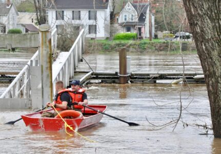
- (File Photo) Marietta Fire Department’s Capt. Eric Moore and firefighter Dan Hammer use a small boat to reach the city docks behind the Armory on Front Street Wednesday morning, April 4, 2024. The pair were on their way to the city’s fireboat that was tied up at the dock. The department removed the fireboat from the river because high water would have made it impossible to take the boat under the Historical Harmar Village Bridge if there was an emergency on the Ohio River.

(File Photo) Marietta Fire Department’s Capt. Eric Moore and firefighter Dan Hammer use a small boat to reach the city docks behind the Armory on Front Street Wednesday morning, April 4, 2024. The pair were on their way to the city’s fireboat that was tied up at the dock. The department removed the fireboat from the river because high water would have made it impossible to take the boat under the Historical Harmar Village Bridge if there was an emergency on the Ohio River.
PARKERSBURG — Rain is expected this weekend with flooding possible in some low lying areas.
The Mid-Ohio Valley is under a flood watch from Saturday morning to Sunday evening, according to Meteorologist Tom Mazza with the National Weather Service in Charleston.
“We have a flood watch in effect for that area and it is quite a large area in fact,” he said. “There is a potential for flooding with 2-plus inches of rainfall on Saturday through Saturday night and into early Sunday.”
The ground has remained saturated from rain and snow early this week, he said.
Mazza advises people to pay attention to the latest forecasts, make sure they have a way to receive warnings and keep track of where the river levels are.
Although some low lying areas might be prone to some flooding, the Ohio River is not expected to flood in Marietta, as the water is expected to crest at 26 feet where flood stage is at 35 feet and in Parkersburg the river is expected to crest at 28½ feet where flood stage is at 36 feet.
Mazza said after the rain moves through the area, the temperatures are expected to get cold.
“It is going to be windy on Monday, cold and then it is going to be cold the entire next week,” Mazza said. “It could be cold enough to freeze Sunday night, but that is borderline.”
He said some areas with water on the roads could freeze as lows are expected in the 20s by Monday morning.
“We could be looking at snow again around Wednesday and Thursday in that mid-week period,” Mazza said.
The flood watch is in effect locally for Washington, Meigs and Athens counties in Ohio and Wood, Pleasants, Tyler, Roane, Wirt, Calhoun, Ritchie and Doddridge counties in West Virginia as well as other counties throughout both states.
“Excessive runoff may result in flooding of rivers, creeks, streams, and other low-lying and flood-prone locations,” according to the flood watch warning. “Creeks and streams may rise out of their banks. Flooding may occur in poor drainage and urban areas. Extensive street flooding and flooding of creeks and rivers are possible.”
The West Virginia Division of Highways is prepared to combat the effects of the severe weather system, according to a press release issued by the WVDOH.
“The WVDOH will have crews all across the state ready to respond to a wide variety of conditions that could occur as a result of the forecasted weather,” said West Virginia Department of Transportation Secretary Stephen T. Rumbaugh, P.E. “By working closely with the West Virginia Emergency Management Division and other crisis partners, including the WVDOT Transportation Management Center, the agency remains ready to serve the citizens of West Virginia who depend on the highway system.”
The WVDOH will actively monitor the road conditions and use proper signage when it becomes necessary to close a road due to high water, road slips or landslides, Rumbaugh said.
“Remember to never drive through high water, stay off cell phones and be mindful of our crews who are out working in these conditions,” he said.
Wood County 911 Director Mike Shook said their emergency services people will be monitoring things and making updates on the Wood County 911 Facebook page.
“People need to be mindful of the streams and the roads that usually are covered with water first, like Core Road and others,” he said. “They just need to keep an eye out and use common sense.”
He advised people not to drive into high water as even 4-6 inches of water would be enough to move a vehicle. If they can, find an alternate route.
In Washington County, the Washington County Sheriff’s Department will be monitoring roadways that are usually affected by high water, said Col. Brian Rhodes of the Washington County Sheriff’s Department.
Those include County Road 9 at Hills Bridge Road, Hills Bridge Road at Handschumaker Road, State Route 26 at mile marker 28, Jett Hill Road at County Road 9, Buells Run Road at State Route 821, Whipple Run Road at Kohl Road, Rainbow Road at Muskingum Road as well as other roadways that typically have high water during heavy rains that are familiar to local residents, Rhodes said.
“Anytime anyone has the opportunity to turn around and find an alternate route that is the safest thing to do,” he said.
If someone ends up driving through water, they need to test their brakes and make sure they are working properly before going at a higher speed.
Deputies will be out monitoring road conditions and will close off roadways if water gets high enough, Rhodes said.
“Again, the safest thing is to turn around and don’t drive through the water,” he said.
Local News

Tulsi Gabbard resigns as director of national intelligence, citing her husband’s health
Local events
Meetings ¯ The Operations Committee of the Warren Local Board of Education will meet at 5 p.m. May 27, at Warren ...

Scalise sworn in as new Wood County emergency management director
Around Town
Click It or Ticket Wendy’s event Wendy’s, 105 Pike St., Marietta, is partnering with the Safe Communities ...

Washington County Commissioners approve Joe Derkin as interim prosecutor
Washington County Grand Jury Indicts 10 People On Drug, Kidnapping And Other Charges
10 people were indicted by the Washington County Grand Jury this week. Indictments include: *Michalle Renea ...