It happened here: Historical markers explain the past
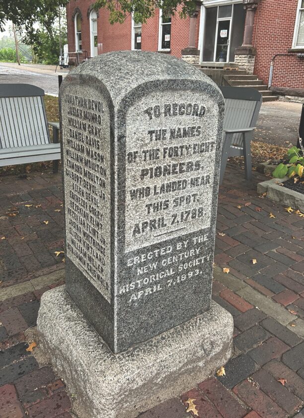
A historical marker near Butler and Front streets in Marietta with the names of those who came to the area in 1788 “near this spot.” (Photo by Art Smith)
We live in an area rich in history. History that is, in many cases, explained with historical markers placed to help you understand what you are standing in front of, next to, or in some cases on top of.
There are hundreds of them in the area — along the streets, attached to buildings, in our parks and even along the rivers.
Some are small, to mark for instance the level of a past flood, while others have so much to say that they are continued on the other side of the sign.
I have always found them to be fascinating because they immerse you in the history literally at the spot, or near the spot where something important once happened.
However, because of the fact that they are cast in metal, or carved into stone, they are not always in line with the modern interpretation of history.
In some cases, different markers can conflict with one another. For years there were two markers that commemorate the Big Bottom Massacre near Stockport. An older marker said “this park is the site of an attack on an Ohio Company settlement by Delaware and Wyandot Indians on January 2, 1791. The Big Bottom massacre marked the outbreak of four years of frontier warfare in Ohio, which only stopped when General Anthony Wayne and the Indian Tribes signed the Treaty of Greene Ville.”
A newer one placed in 2002 correctly pointed out that “despite warnings of Native American hostility, an association of 36 Company members moved north from Marietta to settle “Big Bottom,” a large area of level land on the east side of the Muskingum River. The settlers were acquainted with Native American warfare, but even so, built an unprotected outpost.” As is the case with all writings, consider the source of the material you are reading.
A large stone marker in Marietta placed “to record the names of the forty-eight pioneers who landed near this spot, April 7, 1788” can be found in a small park near Butler and Front streets.
The group on April 7, 1788, landed near Fort Harmer, before crossing the Muskingum and landing near where the Corps of Engineers facility is today. For years the monument sat near Monroe and Post streets where the bike path is today. The term “near this spot” is not completely accurate, but it is hard to change the wording when it is carved in granite.
The website HMdb.org does a great job recording the exact location of historical markers as well as displaying the text of each of them along with photos. The user-contributed site is a great resource to see what has happened around you. There are also a number of mobile apps that you can use on your phone.
The HMdb.org site lists more than 130 markers for Marietta alone and more than 60 for Parkersburg. Nationwide it lists more than 234,000 locations that someone, at some time, thought were important enough to put a sign up explaining what happened there.
They mark things such as:
In Parkersburg
The Point. “It was the site of downtown Parkersburg’s earliest settlement and the stopping place for several famous people. George Washington paused here in his trip down the Ohio in 1770, as did James Monroe in 1785 and George Rogers Clark about the same time.”
Sumner School. “Established in January 1862 thru the leadership of Robert Simmons. First free school south of Mason-Dixon Line. Later named for abolitionist senator Charles Sumner.”
In Marietta
B and O Railroad Bridge. Built on the existing piers as a covered bridge in 1856, converted to railroad use in 1873, back to foot traffic in 1962, it was rebuilt after floods four times.
Boiler Point
Named for this cylinder here on the area once known as Flat Iron Square. The boiler, now largely underground, was ordered by Major John Lawrence Lewis circa 1814, sent by boat from Pittsburgh, PA, in care of Dudley Woodbridge, Jr., whose store stood nearby on Ohio St. Lewis failed to pay the charges; and boiler became a public loafing place.
Our area is in a rather unique position in that a lot of the local history markers are in fact made by a local company named Sewah Studios.
The company has been producing roadside markers out of cast aluminum since 1927. Today they help customers all over the country inform the public with historical markers.
They produce around 100 markers per month from their factory on Mill Creek Road, a location that is, not surprisingly, marked by an historical marker.
Art Smith is online manager of The Marietta Times and the Parkersburg News and Sentinel, he can be reached at asmith@mariettatimes.com
Features
Letter off-base on local residents, risks
A recent letter titled “Ohio Oil and Gas Under Attack by California Funded Leftists from Athens County,” is ...

Antietam
America’s greatest secret weapon
Our grandson is a U.S. Marine. This week I told him about his great-grandfather, my dad, who was a proud U.S. ...
Climate change, extreme weather, and insurance companies
We are homeowners whose entire neighborhoods have been destroyed by fires and we’re fighting our insurance ...
It happened here: Historical markers explain the past
MOV Climate Corner: HB 2014 a dead end
House Bill 2014, the Power Generation and Consumption Act of 2025, introduced on 3/18/25 into the WV House of ...