Connecting trails
April 10 meeting to get public views on tying in Devola path with Marietta’s
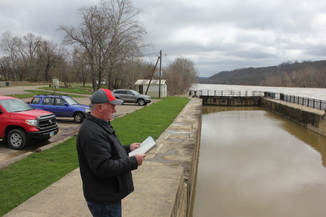
JANELLE PATTERSON The Marietta Times Muskingum Township Trustee Ken Schilling looks over a map of Devola as he talks about possible extensions of the Devola Multi-Use Trail and the Marietta River Trail Monday at the potential destination site, Devols Dam.
The next step is on the calendar in the long-range plan to connect the Devola Multi-Use Path with the River Trail in Marietta.
On April 10 the Muskingum Township trustees are to hold a public presentation and open house at the Devola fire station to discuss potential routes to connect both trails.
Such a connection would expand and combine the pathways, providing more than five miles of dedicated recreational and pedestrian space.
The Devola Multi-Use Path, which sits north of Ohio 821 on the Broughton Nature Preserve, opened in October of 2015 and stretches for 1.1 miles crossing over Second Creek. The Marietta River Trail stretches for 3.28 miles along the Muskingum and Ohio riverbanks with an additional 0.84 miles planned for construction this spring and summer out to the Walmart/Aldi shopping area on the southeastern end of Marietta.
Muskingum Township Trustee Ken Schilling explained that next week’s meeting is to get a better feel for where local residents and users of the trails want these connections to be, and how the trail should head north next.
“Where do the community and the stakeholders feel most comfortable taking it?” said Schilling. “You’ve got different groups that may have an interest, of course, the cyclists and avid runners but also the young families that may not want to be near state highways for safety reasons. I’m interested in hearing their perspectives, too.”
The meeting is a part of the grant-funded engineering study being performed by Woolpert’s Engineering, which also contributed to both the current Marietta River Trail and the coming extension this summer.
“There are lots of challenges, some technical and others simply of who is using this,” explained Ron Mattox, practice leader for the firm. “The challenge of staying along the riverbank is the range of private property and easements that would have to be acquired, but elsewhere if you go up a hill you’re dealing with some slip-prone areas and also how to remain (Americans with Disabilities Act) compliant and accessible.”
The meeting will be to gather feedback, both Mattox and Schilling said.
Available at the meeting will be drawings on topographic maps of where different connections between the two trails could be made, and which routes future trails could take.
“This discussion started two years ago with (The Ohio Department of Transportation) and has evolved to this study paid for by the Wood-Washington-Wirt Interstate Planning Commission,” explained George Banziger, who is a member of the multi-use path committee that brought about the Devola trail. “This study is not about specific dollar amounts to construct the trail, but more about which options we have, and in general to know how many, say, bridges or grading would be needed, and how that could be a bigger factor in costs.”
Ryan Smith, co-owner of the Marietta Adventure Company, and president of the River Valley Mountain Bikers Association, said his primary desire for the trail is to connect Devola’s current trail to Marietta’s.
“That corridor from (OH) 821 down 60 and Muskingum Drive into Marietta is very congested and not really cyclist friendly,” he said. “In heavy traffic, you wouldn’t feel safe on a bike ride with your child down that corridor.”
One option to negate that safety concern is to extend the Marietta trail behind homes and businesses along Muskingum until reaching the stretch between the river and Ohio 60 before the House of Wines.
Another, according to Schilling, is to jump into the hospital area and back behind the Rathbone neighborhood near the high school.
The planning of the recreational trail includes considerations for different entry points, with available parking.
“There are families in Devola, do they want the trail to come out to the picturesque location at Devol’s Dam?” said Schilling. “But then there’s also the dream of eventually having a dedicated trail from Marietta up to Zanesville. Do we detour, or do we head farther north?”
Schilling said the upcoming meeting will include two 15-minute presentations followed by question and answer sessions with the engineering firm about the feasibility of different options.
The first of the presentations will be held at 4:30 p.m. and the second at 5:45 p.m.
“We want as much input as possible, that’s why we’ve placed the meeting at a location with plenty of parking and are holding it after the general workday,” he added.
If you go
¯ What: Public Meeting to discuss the future extension and connection of Marietta River Trail and Devola Multi-Use Path.
¯ When: 4:30 to 6:30 p.m. April 10.
¯ Where: Devola Volunteer Fire Company, 1286 Masonic Park Road.
¯ Questions/comments may be directed to Muskingum Township at 740-373-0189, or Township Trustee Kenneth Schilling, 740-629-1472.
Source: Muskingum Township Trustees.
Local News

Picture This: Marietta City Schools Board of Education meeting

Scam warned by state and local authorities
Blennerhassett Island to open 2026 season Friday
Around Town
Gospel meetings Gospel meetings will be held through Wednesday at the Ullman Street Church of Christ, 512 Ullman ...
Artsbridge calendar of events
The Artsbridge calendar of events for the week: Today: Diane Wigal wildlife photography art exhibit, 9 a.m. to 4 ...