Minimal damage reported after tornado confirmed in Athens County
-
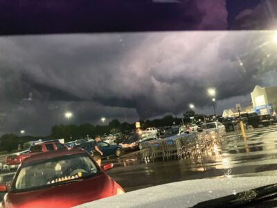
- Davisville resident Brittany Hensley took this picture of the sky outside the south Parkersburg Walmart, looking toward Mineral Wells, Saturday evening, with what looked to her like a funnel cloud in the center. The National Weather Service issued a tornado warning for parts of Wood County Saturday night but has not confirmed a tornado. (Photo Provided)
-

- This screen grab from a video shared by Nelsonville resident Adam Fowler shows what appears to be a funnel cloud forming east of the Athens County Fair Saturday evening. The National Weather Service confirmed an EF1 tornado touched down in the area Saturday. (Photo Provided)

Davisville resident Brittany Hensley took this picture of the sky outside the south Parkersburg Walmart, looking toward Mineral Wells, Saturday evening, with what looked to her like a funnel cloud in the center. The National Weather Service issued a tornado warning for parts of Wood County Saturday night but has not confirmed a tornado. (Photo Provided)
ATHENS, Ohio — The National Weather Service confirmed a tornado touched down in Athens County Saturday night, but despite warnings in the area throughout that evening, minimal damage was reported Sunday.
“We were very fortunate,” Athens County Emergency Management Agency Director Don Gossel said Sunday evening. “Our biggest problem really was there was a little over 100 people without power.
The Weather Service issued a Public Information Statement just before 4 p.m. Sunday confirming an EF1 tornado — the second-lowest level and classified as weak on the Enhanced Fujita Scale — in the county.
It touched down near Angel Ridge Road, southeast of Athens at 7:33 p.m. and traveled north-northeast, about 2.33 miles, before lifting just beyond Kincade Road, the statement said.
“Damage was limited to snapped and uprooted trees and some snapped power poles along the path, with the worst damage occurring in a 300-yard swath along Long Run Road,” it said.
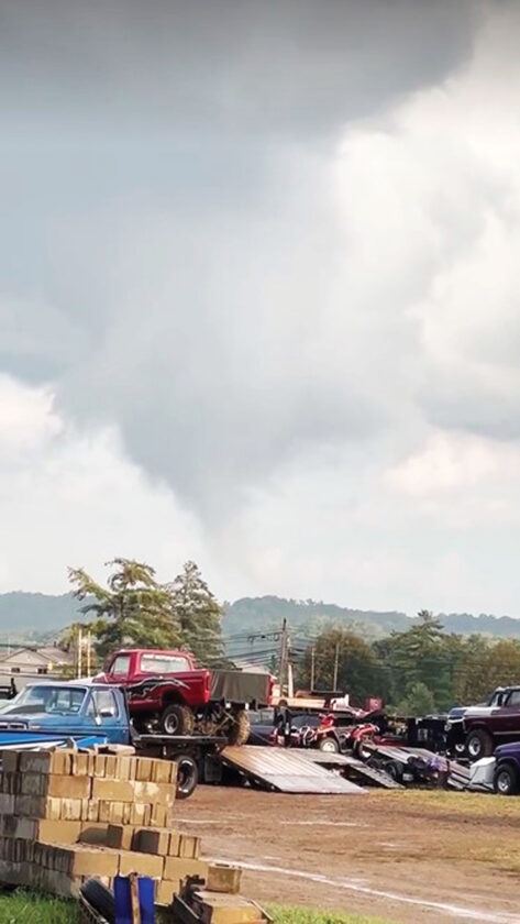
This screen grab from a video shared by Nelsonville resident Adam Fowler shows what appears to be a funnel cloud forming east of the Athens County Fair Saturday evening. The National Weather Service confirmed an EF1 tornado touched down in the area Saturday. (Photo Provided)
Gossel said two houses were located about 20 yards off the path, but neither reported any direct damage.
The funnel cloud’s formation was visible to people at the Athens County Fairgrounds for the final night of the county fair.
Nelsonville resident Adam Fowler was waiting for the truck and tractor pull to start up after a rain delay. Someone said it looked like smoke was rising in the distance, and Fowler looked in that direction. Soon, he had his phone out, recording a video that was shared on social media.
“We (saw) the rotation, the funnel cloud starting to form out,” he said.
Fowler said he wasn’t very worried because it was clear the clouds were past the fairgrounds and “you could tell it was moving away from us.”
The Weather Service said it was the seventh tornado documented in Athens County and the first since 2018.
Between 7:35 and 9:34 p.m., the Weather Service issued tornado watches for portions of Athens, Washington and Meigs counties in Ohio and Wood, Doddridge, Pleasants and Tyler counties in West Virginia.
Davisville resident Brittany Hensley was at the south Parkersburg Walmart when the warning came down. People were told to stay in the store for 15 or 20 minutes, she said. Hensley wasn’t overly concerned when she left the store, got in her car and looked in the direction of Mineral Wells, where she spotted something that looked very much to her like a funnel cloud.
“It was just nice and calm,” she said. “It was kind of crazy, ’cause Walmart’s never calm.”
Hensley snapped a picture of the foreboding scene and shared it online.
Despite the foreboding visuals, Wood County Sheriff Rick Woodyard and county 911 officials said they received no calls about storm damage.
“I was ready to saddle up and we didn’t get any report of any damage, any significant amount,” Woodyard said.
The same was true in Washington County, according to a dispatcher with the sheriff’s office there. And a dispatcher with Central Communications serving Ritchie and Doddridge counties said they only had a couple of downed trees.
Tom Mazza, a lead forecaster with the office, said Sunday afternoon that areas were being surveyed to confirm possible tornadoes. On Sunday evening, meteorologist Andy Roche said he did not anticipate any other reports being issued.
Roche said the conditions on Saturday included heat, humidity and wind, ingredients for organized storms that can produce tornadoes.
“The ingredients were ideal in the atmosphere for severe weather,” he said.
Local News

Local students celebrate achievements
Artsbridge calendar of events June 9-15
The Artsbridge calendar of community of events: Today Noah Strickler Photography art exhibit, 9 a.m. to 4 p.m., ...
WVU Parkersburg announces spring grads
WVU Parkersburg has announced its Spring 2026 graduates who have earned certificates, associate’s and bachelor's ...
Washington County Commissioner Charlie Schilling testifies to Ohio Joint Data Center Committee
Local events
Meetings ¯ The Washington State College of Ohio Board of Trustees will hold its monthly meeting at 4 p.m. June ...
Legal Aid receives funding to prevent homelessness awarded by Parkersburg
PARKERSBURG – Legal Aid of West Virginia has received funding from the city of Parkersburg to prevent ...