Floods still hanging on in W.Va.

Blennerhassett Island is seen Thursday afternoon in this shot from a drone as the Ohio River level continues to rise.
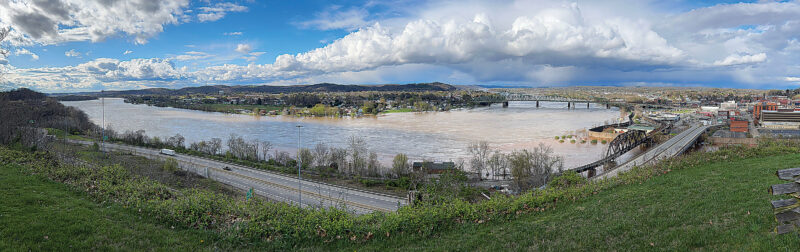
Photo by Art Smith
The flooding Ohio River flows past Parkersburg and Belpre late Thursday afternoon before cresting on Friday
PARKERSBURG – With the Ohio River cresting Friday, local officials are now waiting for the water to recede so people can begin the process of assessing damage and beginning cleanup efforts.
“Right now we are waiting for the water to go down and see what it reveals,” Wood County 911 Director Mike Shook said. “That is when people start calling in and determining what their damage is.”
The Ohio River at Parkersburg crested at 41.1 feet at around 11:15 a.m. Friday. Flood stage is 36 feet. Tygart Creek was reported at 15.61 feet at 12:15 p.m. Flood stage is 11 feet. Shook said the water was starting to recede Friday afternoon.
“It should go down a lot quicker than it went up,” he said, adding he is expecting sometime on Sunday will be the time when flooded areas will clear out.
As of Friday, many of the areas that have flooded were still flooded.
“Nothing has really changed on that,” Shook said. “It won’t change for another six to seven hours” he said just before 1 p.m. Friday.
“Some roads are still covered and people need to avoid them.”
The Wood County Sheriff’s Department reported a woman who died Thursday after her SUV became submerged in flood waters. Valerie Swisher, 49, of Davisville, was pronounced dead at the scene off of Nicolette Road in the Davisville area around 7 p.m. Thursday, according to a news release posted on the Wood County Sheriff’s Office Facebook page.
Shook said it doesn’t take much water for a vehicle and its occupants to get into trouble.
“You don’t know how swift that water is moving until you are in it,” he said, adding he advises people they shouldn’t even attempt it.
Wood County Sheriff Rick Woodyard said at just after 1 p.m. Friday that the situation was “stable.”
“It hadn’t changed much,” he said.
Other than the fatality, there have not been many emergency issues Thursday into Friday. He also reminded people not to drive over flooded roadways.
“If you can’t see the roadway, don’t cross,” Woodyard said.
He believes a lot of the roadways that are flooded will start receding on Saturday.
Superintendent Craig Pyles of the Blennerhassett Island Historical State Park said that the high water is impacting Blennerhassett Island, but that the mansion and the artifacts inside are “safe.”
Pyles said when the mansion was rebuilt they raised it up over eight feet to get it out of the floodplain.
However, the concession stand, the restrooms and the gift shop have taken in some water.
Crews are planning to go over to the island on Monday or early next week to assess any damage and begin cleanup efforts.
“We have been through this before,” he said, adding he had maintenance personnel who have been through flooding before and are ready to get to work.
Officials are still planning to have the park’s opening day on April 30.
Pyles noted the water from the river has reached the flood gate at Point Park where the city installed the barrier the other day.
They have a flood exhibit at the Blennerhassett Museum of Regional History at Second and Juliana streets. If the floodwall was not in place, the water would have already reached the first floor of the museum, Pyles said.
“It is definitely doing its job,” he said.
A flood warning remains in effect for the Ohio River at Willow Island Lock affecting Washington, Tyler, Wood and Pleasants counties as well as the Ohio River at the Belleville Lock affecting Jackson, Wood and Meigs counties as moderate flooding remains in the forecast.
The warning is in effect for Willow Island until Saturday afternoon. The warning for Belleville will be in effect until early Sunday afternoon.
Sharon Kesselring, executive director of the American Red Cross of the Ohio River Valley, said residents who have experienced flooding in a living space should call 1-800-RED-CROSS and submit their information.
It will be forwarded to the local level, where personnel will do damage assessments to determine if individuals are eligible for assistance.
They were doing some Friday, but Kesselring noted “there are lots of places we cannot get to because the water has not yet receded.”
The National Weather Service in Charleston is forecasting partly sunny skies Saturday with a high of 52. It will turn to mostly cloudy skies by Saturday evening with a low of 29. It is expected to be sunny Sunday with a high of 61 with a 40% chance of showers expected Sunday night. It is expected to be partly sunny Monday with a high near 72.
City Editor Evan Bevins contributed to this story.
Contact Brett Dunlap at bdunlap@newsandsentinel.com
Local News

Rotating exhibit space aims to accelerate learning at Discovery World

Marietta Trolley returns May 2 for 2026 tour season

Mid-Ohio Valley Career Connect Job Fair set for April 8
Parkersburg mayor offers way for petitioners to remove signatures
PARKERSBURG — As a committee seeking to repeal or place on the ballot an ordinance authorizing a trash service ...

Backers urge Ohio lawmakers to require absentee voters to mail in copy of ID