
Trending
When I first arrived in Marietta as a nerdy young teenager, I wondered why the Ohio River was in fact in the neighboring state of West Virginia. It just seemed odd to me that a river with the same name as the state would not be in that state. Here in southeastern Ohio the river and all the islands are part of the Mountain State, not the Buckeye State. Further down the river it is part of Kentucky. The only part of the river that is in Ohio is a thin strip of water near the northern bank of the waterway.
In colonial times Virginia was immense and included what is now West Virginia, Ohio, Kentucky and Indiana. After the Revolutionary War they gave up much of it to form other states. Virginia gave up the land, but not the river. When Kentucky was formed, they kept the same rule in place.
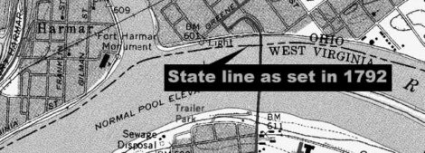
To this day the boundary between Ohio and its southern neighbors remains at the northern edge of the river. The river as it was in 1792. The river is, of course, different than it was 230 years ago. For one thing, large dams have been built that have raised the depth, and therefore the width of the river by several feet. Rivers move somewhat on their own as well. A great example is the island near Marietta that has slowly moved upstream over the years. It once reached well below the Williamstown Bridge.
None of these matters though. The border is as it was in 1792, just four years after the first people of European descent arrived to carve Marietta out of the "frontier" of the time. The river was the only superhighway and controlling it was not only a matter of state pride, but also a source of revenue. It still is. Take a ride on a boat on the Ohio River and purchase something to drink, you are paying tax to West Virginia, not Ohio, even if the boat left from Ohio.
Ohio has fought court cases about the border. In 1980 a case ended up in front of the U.S. Supreme Court. In Ohio v. Kentucky they argued that the boundary between the states should be in the middle of the river, as it is in nearly every instance around the country where a waterway forms the line between the states. The case was interesting because Kentucky wanted the border moved to the current low water mark, which would have given the state more area. Ohio wanted it moved to the middle of the river, or at the very least to have it left at the 1792 level.
The case cited an earlier one where Indiana sued Kentucky. Because Virginia was already a state when it gave up the land northeast of the river, the border was fixed at the edge of the 1792 river level. This fixing of the border has led to some instances where former islands are now attached to the northern border state but are still in the southern state. Green River Island in Kentucky is one of many examples of land that seems to be connected to the wrong state.
It is not an island anymore and in fact has a large revenue generating horse track on it but is not part of Indiana because of the 1792 border.
Here in the Mid-Ohio Valley, this mainly means that the maintenance of bridges falls on West Virginia and not Ohio. Modern topographical maps clearly show the Ohio-West Virginia border slightly offshore in Marietta. The line gives a little insight into where the river was when the first people of European descent arrived here in 1788 and what 230 years of damming, flooding and the natural wandering of the waterway has done to the riverbank and also explains why the "Welcome to" signs for each state is over the river and not the riverbank.
***
Art Smith is online manager of The Times; he can be reached at asmith@mariettatimes.com.