Before there was Marietta, there was Fort Harmar
The unique Marietta neighborhood of Harmar celebrates Harmar Days this weekend. The community has deep roots, deeper in fact than the city of Marietta. Before there was Harmar the community, there was Fort Harmar and before there was Fort Harmar there was Josiah Harmar for which the area, and the large hill next to it are named.
Josiah Harmar was born in Philadelphia in 1753 and became a captain in the Continental Army in 1776. Promoted several times throughout the Revolutionary War, by 1784 he was the lieutenant colonel commandant of the first American Regiment and was the senior officer of the United States Army.
He was instrumental in establishing military outposts in the new western lands being opened after the war. Forts constructed included Fort Steuben near present-day Steubenville and Fort Washington, which was near the heart of what is now downtown Cincinnati and Fort Harmar at the confluence of the Ohio and Muskingum rivers.
The forts, all constructed from wood, were built to have multiple purposes. They provided refuge and shelter for those surveying the lands for future use or those moving west. They also were used to deter people from illegally squatting on the land without purchasing it. They were also used as government outposts from which to negotiate with the Native Americans who had lived in the area for generations and then to provide a military presence up and down the river when those negotiations failed.
A reconstructed version of Fort Steuben now stands near Ohio 7 as it passes through Steubenville, hosting thousands of school children and adults per year. It provides a real link to the past.
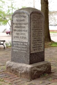
Fort Harmar, located between Steubenville and Cincinnati, provided stability to the area that would become Marietta. The fort and those stationed there predate the arrival in 1788 of the members of the Ohio Company that came to “settle” the area. In fact, the soldiers helped pull the flatboat in when the group overshot the mouth of the Muskingum on a rainy April morning. The fort provided security for the young city being developed across the Muskingum and an official spot to conduct governmental business. The Treaty of Fort Harmar, designed to get more western lands for settlements, was signed there.
The fort was constructed in 1785 by troops under the command of Major John Doughty. It was constructed on a shelf of land near where the former Harmar School stands today. The five-sided structure provided a commanding view of the Ohio River. The walls surround an area of about three quarters of an acre according to “Pioneer History; Ohio Valley and the Early Settlement of the Northwest Territory,” published in 1848. Each 120-foot wall was built from timber placed horizontally 12-14 feet high.
Dwellings and other structures were built along the inside walls. The main gate faced the river, in the middle was a well. Just outside the walls were large gardens to raise food for soldiers. In addition to vegetables, peach trees provided fruit. The “Doughty peach” was cultivated in Marietta as late as 1848.
As the push for land and the resulting conflict with the native population moved west, so did the efforts of Josiah Harmar who, for a time, had occupied the fort in Marietta named for him. He established Fort Washington in Cincinnati, and that fort stood near what is now the intersection of Third and Broadway in Cincinnati. In an act of early recycling, much of the Fort was built with the lumber of 40-50 Kentucky flatboats that were purchased for a few dollars and taken apart after the families that had used them completed their journey west.
Harmar ended his military career after the disastrous defeat against the Native Americans at the Battle of the Maumee. So bad was the defeat that he requested to be court-martialed. Harmar ended up moving back east, dying in Philadelphia in 1813.
Back in Marietta, the giant old Sycamores that once held the riverbanks in place near the fort were long gone by the middle of the 1800s. The once narrow mouth of the Muskingum slowly widened to the point that most of the fort site was swallowed by the rivers. Construction of dams on the Ohio would later raise the river level around 10 feet.
The site eventually became a market and then was used for construction of two different schools.
The future use of the Harmar School that sits on the land today is uncertain. A local group called the Fort Harmar Heritage Group wants to turn it into a new green space for the city. In the plan, a flat outline of the fort would provide a link back to the original use of the land while at the same time providing current residents a location to enjoy the two rivers.
Art Smith is online manager for The Times, he can be reached at asmith@mariettatimes.com
Local Columns
The promise of heat batteries for cleaner air
The Mid-Ohio Valley stands at a pivotal moment in its industrial history, if its businesses choose to lead and ...
The highs and lows of being a photographer
Give us today our daily bread
Smart people are interested in prayer. Seventy-six percent of Americans claim that they pray, and 50% report that ...
An unsettled life

Fall care for the herb garden
What it means to say that Jesus is King
By Mark Wilmoth In his book, Follow Me, David Platt points out that while churchgoers are often invited to “make ...